Welcome to Plitvice Lakes National Park!

Discover Plitvice Lakes
Plitvice Lakes National Park is Croatia’s best-known national park, listed on the UNESCO List of World Heritage sites. It is a popular visiting destination all year round, and must-see for every visitor to Croatia.
Well known for its system of cascading lakes - whereby sixteen lovely lakes are interconnected by cascades and waterfalls. The park is simply beautiful. The main focus of park's beauty are sixteen lakes, divided into two parts - Gornja jezera (Upper lakes) and Donja Jezera (Lower Lakes), as well as numerous waterfalls and cascades.
Located in Lika, covering the region that is bordered by mountains Mala Kapela, Medveđak and Gornja Plješevica, National Park extends over an area of just under 30 thousand hectares (about 300 square kilometres), including forests (14 thousand hectares), water, meadows, pastures as well as scattered hamlets in between (Rastovača, Poljanak, Jezerce,Plitvica). It is a habitat of eleven forest communities including beech, fir, spruce and pine species.
The Park is also populated by variety of animals including bears, wolves, otters, wild boars, skunks, squirrels, rabbits, foxes and numerous bird species.
The region is established as National Park in April 1949, declaring Plitvice Lakes as the area of a exceptional natural beauty. That was first National Park in Croatia. Later on, in 1979, Plitvice was put by UNESCO on the of World's cultural and natural inheritance.
Explore 16 Interconnected Lakes
 Sixteen interconnected lakes are grouped in Upper and Lower Lakes (see large map here). The highest lake is Prošćansko situated at the altitude of 639 m while the lowest is Novakovića Brod at the altitude of 503 meters.First part of the Upper Lakes are formed as extension of basic substrates dolomite while Lower Lakes is the limestone canyon that extends into the canyon of Korana river:
List of lakes:
 Prošćansko Lake - the first and highest lake, located on an altitude of 638 meters above the sea level.
It is also the second largest lake in the whole lake system.
The lake covers the total area of 68 hectares with a depth of 37 meters. - read more and see photos
 Ciginovac Lake - also known as Ciganovac and Cigino jezero is the second highest lake in the whole lake system, located on an altitude of 626 meters above the sea level.
It covers the total area of just over 7 hectares with a max depth of 11 meters in the very middle of the lake - read more and see photos
 Okrugljak Lake - also known as Okrugljaj and Kruginovac is the third highest lake in the whole lake system, located on an altitude of 613 meters above the sea level.
The water here covers the total area of just over 4 hectares with a max depth of 15 meters at its southern shores, right at the very bottom of Labudovačka barijera (barrier). - read more and see photos
 Batinovac Lake - Batinovac jezero also known as Bakinovac is the fourth highest lake in the whole lake system, located on an altitude of 610 meters above the sea level.
One among the smallest lakes, covering the total area of just over 1 hectares with a max depth of 5 meters in the very centre of the lake.
 Veliko jezero Lake - (Lake Veliko) also known as Jovinovac veliki (Large Jovinovac) is the fifth highest lake in the whole lake system, located on an altitude of 607 meters above the sea level. It is one among the smallest lakes, covering the total area of just under 2 hectares with a max depth of 8 meters. - read more and see photos
 Malo jezero - Malo lake is also known as Jovinovac mali (Small Jovinovac), the sixth highest lake in the whole lake system, located on an altitude of 604 meters above the sea level. It is one among the small(er) lakes, covering the total area of just over 1 hectare with a max depth of 9.5 meters. - read more and see some photos
 Lake Vir - Jezero Vir is the seventh highest lake in the whole lake system, located on an altitude of 598 meters above the sea level. The smallest of all lakes, covering the total area of under 0.6 hectares with a max depth of 4 meters. The max length of the lake is about 47 meters while the max width is about 56 meters. - read more
 Galovac Lake - the eight highest lake in the whole lake system, located on an altitude of 582 meters above the sea level. It is one among the larger lakes (third largest), covering the total area of just over 12.5 hectares with a max depth of 24 meters in the northern part of the lake, in a vicinity of Stubice hill. - read more
 Lake Milino jezero - (Milino Lake) is the ninth highest lake in the whole lake system, located on an altitude of 564 meters above the sea level. It is one of the smallest lakes, covering the total area of just under 1 hectares with a max depth of just one meter in the central part of the lake. - read more
 Gradinsko Lake - also known as Jezerce is the tenth highest lake in the whole lake system, located on an altitude of 554 meters above the sea level. It is one among the largest lakes, covering the total area of 8.1 hectares with a max depth of 10 meters on several locations around the lake - read more
 Burgeti, Bukovi Lakes - also known as ‘Bukovi‘ or ‘ Buk‘ is the eleventh highest lakes in the whole lake system, located on an altitude of 534 meters above the sea level. These tiny lakes or ponds, mutually interlinked are fed by waters from Gradinsko Lake. They are separated by porous travertine barriers covered by low vegetation. - read more
 Kozjak - Jezero Kozjak is the last and lowest of Upper Lakes, located on an altitude of 534 meters above the sea level. It is also the largest and deepest lake in the whole lake system. The water covers the total area of 82 hectares with a depth of 47 meters. It also features small island Stefanijin otok - read more
 Milanovac Lake - the first and highest lake in Plitvice Lower Lakes, located on an altitude of 524 meters above the sea level. It is among the smaller lakes in the whole lake system but the largest in the Lower Lakes. The water covers the total area of 3.2 hectares with maximum depth of 18 meters. - read more
 Gavanovac - also known as Gavanovo jezero is the second highest lake in Plitvice Lower Lakes, located on an altitude of 518 meters above the sea level and one among the smallest lakes in the whole system – it covers the total area of just under 0.8 hectares with a maximum depth of 10 meters. - read more
 Kaluđerovac - also known as Kaluđerovo jezero is the third highest lake in Plitvice Lower Lakes, located on an altitude of 508 meters above the sea level. It is one of the largest lakes in this part of the system, covering the area of just over 2.1 hectares with a maximum depth of 14 meters. - read more
 Novakovića brod - Novakovića Lake is the latest and lowest lake in Plitvice National Park, located on an altitude of 503 meters above the sea level. One of the smallest lakes covering the area of just under 0.4 hectares with a maximum depth of 3 meters. The length of the lake is 90 meters while the width is 50 meters. It belongs to a group of Lower Lakes. - read more and see photos
Cross section diagram of Plitvice lakes:
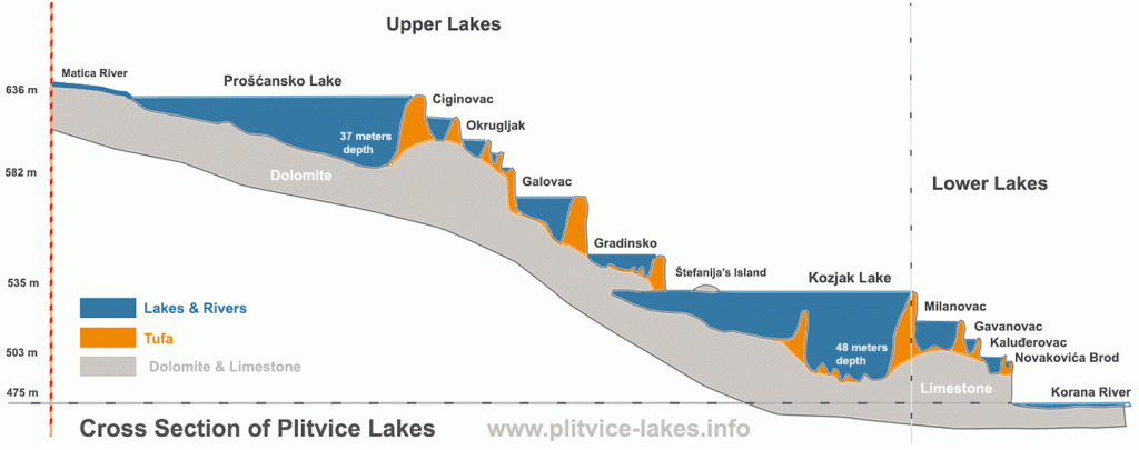 Cross Section Diagram of Plitvice Lakes, Croatia - showing the source where Matica river fills with water Proscansko Lake all the way down, across the 16 lakes to Korana river. Click on above diagram to see the large version of the image.
Getting to Plitvice
 National Park is easy to reach from Zagreb, Split, Sibenik and Zadar as well as from other surrounding places. You can also do a nice stop over in Plitvice if you travel from Zagreb to the Adriatic coast especially if you drive. Visiting Plitvice from other places takes bit longer, sometime 4 to 6 hours travelling by bus or driving so day trip is not easy to do and visit to Plitvice lakes would need to involve overnight stay...read more